
Slope Stabilization Solution Near High Traffic Highways
Charles Allgood, P.E., Principal Engineer with Ground Improvement Engineering in Minnesota, shares an embankment repair project in Carlton County that avoided over-excavation and backfill beneath a high-traffic highway.
A 150-foot section on the south side of a county/state highway in Minnesota’s Carlton County had continuing stability issues with the risk of shallow slope failures. The embankment slope had an approximate inclination of 3:1 with a height near 20 feet. County officials needed a way to stabilize the slope while managing highway traffic.
Test boring and three cone penetrometer soundings down the slope found about 19 feet of moist, medium stiff to stiff clay fill underlain by saturated medium stiff to stiff, fat native clay. The single boring measured the groundwater level about 48 feet below the highway surface.
One method considered was over-excavation in the slope and the complete highway area to 10 feet deep or greater, then backfill with select granular fill with geogrid layers. The county and project partners determined that another option was ground improvement using the Geopier SRT® system, also known as the Plate Pile™ method.
The slope improvement design included geometric information from the County, the geotechnical data, and performance of slope stability analyses. The analyses modeled the unreinforced conditions with an iterative approach to achieve a minimum safety factor of 1.3 with the insertion of Plate Piles.
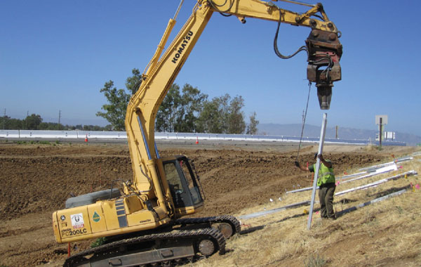
The construction was based on the design and field layout of the Plate Piles; the piles were installed with a CAT 316 excavator and skid steer. This approach of strengthening the existing soils was more economical, faster, and less intrusive on traffic flow compared to over-excavation and soil replacement methods.
The installation team used the skid steer to bring plate piles over to the work area, 129 piers in total. The excavator driver used the hydraulic hammer with a special driving attachment; the equipment could install all the piles from the pavement surface — which occurred over two days. The piles went to depths of 13 feet and had a plate section of 52 inches by 12 inches. The tops of the piles were 12 inches below the ground surface to allow for easier slope regrading at the conclusion of the project.
Related to this article on slope stabilization, you may be interested in our whitepaper outlining levee slope stabilization near a power plant in Missouri using the Geopier SRT slope stabilization method.
Client: Carlton County Highway Department
Geotechnical Engineer: Twin Ports Testing, Superior, WI
General Contractor: Carlton County
Geopier Designer: Ground Improvement Engineering
Geopier Installer: Peterson Contractors, Inc., Reinbeck, Iowa